2016 Annual Report
Alameda County
The Alameda County Flood Control and Water Conservation District works to protect Alameda County residents and businesses from damaging floods.
The District analyzes, plans, designs, constructs, and maintains flood control infrastructure and facilities such as natural creeks, channels, levees, pump stations, dams, and reservoirs.
2016 Annual Report
Director's Message
Many parts of Alameda County received more than two hundred percent of average precipitation during the 2016-2017 winter season. Our hills are green, California’s severe drought is over, and Alameda County’s creeks are flowing with abundance.
Throughout the season, Alameda County Flood Control and Water Conservation District staff closely monitored weather forecasts and measured stream flows. I’m happy to report that this winter, little to no flooding occurred in Alameda County.
The Bay Area received soaking rains early in the season. Our ground became saturated and could not absorb much more water. When more storms rolled in, National Weather Service issued two major flash flood warnings for Alameda County.
We were lucky, though. The intense storm cells veered away from Alameda County. While we received much rain over the season, the rainfall was not as heavy or intense as it might have been. Our flood control system was able to handle the sustained flows.
Still, Alameda County sustained damage from the storms in the form of creek bank erosion, road wash-outs, and downed trees. The storms pointed out weak links and choke points in our flood control system.
The District is working now on short-term repairs, mid-term capital improvement projects, and long-term planning to fortify our flood defenses for today and into the future. These improvements will require significant more funding than the District currently has available. We must keep in mind that preventing flooding is ultimately much less costly than having to recover from flood damage.

With such a dramatic amount of rain, how did we avoid the kind of flooding that some of our neighbors experienced?
2016 Annual Report
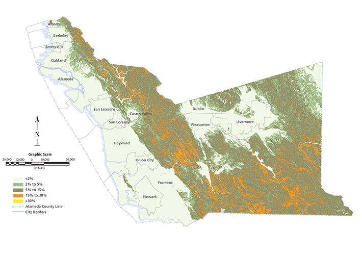
Average Precipitation
Many parts of Alameda County received more than two hundred percent of average precipitation during the 2016-2017 winter season.
2016 Annual Report
Highlights
H&H Manual
This year, the District completed a long-awaited, major upgrade of its Hydrology & Hydraulics Manual that provides guidance to improve the design of the county's flood control facilities.
Learn moreThe Flood Control District’s Hydrology & Hydraulics Manual update reflects a major advance in flood control science and engineering. The District analyzed and modeled decades of hydrologic and meteorological data from Alameda County and surrounding areas.
The procedures presented in the updated manual provide a more accurate prediction of runoff and stream flow resulting from various storm events. By following the guidelines set forth in this manual, engineers and hydrologists can more accurately predict the stormwater flows and then design storm drains, channels, and ponds to prevent flooding.
The District’s Hydrology & Hydraulics Manual is available online, free-of-charge.
Close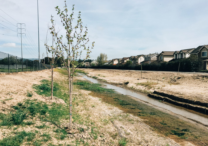
Ardenwood Creek
Ardenwood Creek in Fremont had become choked with sediment and cattails. The District excavated and re-contoured the earthen channel and improved the culvert crossings to restore flood control capacity.
Learn moreInitially constructed in the 1980's as part of a residential development, Ardenwood Creek (Line P) was designed to drain water from Fremont’s urban and suburban neighborhoods to a marsh at the foot of Coyote Hills Regional Park. Over the years, the creek channel silt and sediment built up in the channel, and the banks had eroded. Cattails also aggressively invaded the creek, resulting in reduced flow capacity.
The project, overseen by the Alameda County Flood Control District, includes excavating and re-contouring the earthen channel and improving the culvert crossings at Ardenwood Boulevard and Paseo Padre Parkway.
Wherever possible, the District also tries to restore natural habitat. On Ardenwood Creek, invasive species were replaced with native plants, and the channel improvements have created more diverse riparian and seasonal wetland habitats.
Close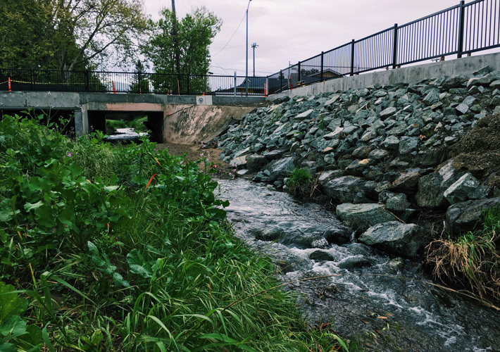
Mission Creek
Stormwater flows off the flanks of Mission Peak into Mission Creek (Line L). The District completed major channel improvements on a half-mile stretch just upstream of Lake Elizabeth.
Learn moreThe portion of Mission Creek (Line L) that flows through Fremont’s Gomes Park and nearby neighborhoods into Lake Elizabeth was originally designed to handle 15-year stormwater flows. The creek banks had eroded in several locations, causing sediment to flow into Lake Elizabeth. The Fremont Park golf course flooded regularly.
The District undertook a major project to widen the existing creek floodplain terrace, add culverts at a street crossing, and enlarge portions of the channel cross section so that Mission Creek could accommodate a 100-year storm.
The creek channel was naturalized, and where possible, non-native and deteriorating trees were removed and replaced with native trees and vegetation. A pathway was also built along the revitalized creek so pedestrians and bicyclists can enjoy its natural beauty. An added benefit is that now nearby property owners will not be required to buy costly flood insurance.
Close
Zone 12 Master Plan
The District is preparing a long-range drainage master plan for “Zone 12,” which covers Oakland and Emeryville. The master plan presents the science behind decisions on projects the District will design and build to manage stormwater flows.
Learn moreWith limited funding available to manage Alameda County’s flood control system, the District must plan its capital improvement program wisely. The District prides itself on offering best value to Alameda County’s taxpayers, relying on strong science to guide its priorities.
The District has completed comprehensive drainage master plans for Zones 3A and 6, and this fiscal year made significant progress toward a Zone 12 master plan. The Zone 12 watershed covers approximately 80 square miles in Emeryville and Oakland and encompasses Temescal, Glen Echo, Trestle Glen, Sausal, Peralta, Courtland, Seminary, Lion, Arroyo Viejo, Elmhurst, and Stonehurst Creeks and their tributaries, the San Lorenzo Creek Federal Project, along with numerous District lines.
Using hydrologic and hydraulic principles along with sophisticated computer modeling, District engineers are better defining the deficiencies and improvements needed to handle 100-year and 25-year stormwater flows in Zone 12.
Close
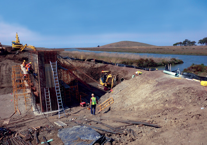
Cull Creek Restoration
Cull Creek flows from high in the hills above Castro Valley to Cull Reservoir and then into San Lorenzo Creek. The District is wrapping up a major restoration project to modify the Cull Reservoir dam and return Cull Creek to its natural meandering channel.
Learn moreAlameda County Flood Control District built Cull Canyon Dam and Reservoir in 1963 for recreational and flood control purposes. The reservoir quickly filled with sediment, requiring several costly sediment removal programs, one in 1974, and another in 1999 and 2000. In 2005, the District concluded that the Cull Creek Dam might be unsafe in a major earthquake.
District engineers devised an innovative project that addresses seismic instability concerns, restores Cull Creek to near natural conditions, and offers new recreational opportunities. Construction on the Cull Creek Dam Spillway Modification and Creek Restoration Project began in July 2016 and is nearly complete.
The existing Cull Canyon Dam spillway was lowered by about ten feet, and sediment within the old reservoir was excavated to use as grading material for the downstream Cull Creek restoration.
Cull Reservoir will hold some water during heavy rainstorms. On the off-season, though, the reservoir reverts to the meandering Cull Creek surrounded by open space and a lush meadow. Another huge added benefit of the project may not be as obvious. By allowing sediment to flow naturally downstream, the creek bed and banks in downstream San Lorenzo Creek will become more stable as sediment heals and restores some currently unstable segments.
Close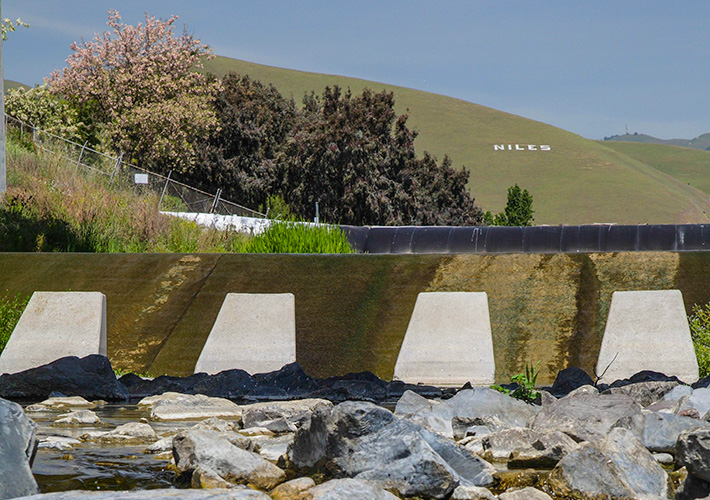
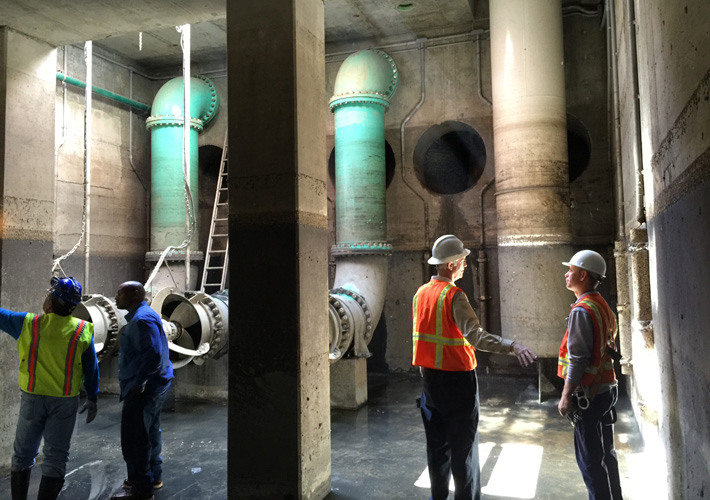
Alameda Creek Fish Ladder
Ever since steelhead trout were first spotted in Alameda Creek nearly two decades ago, the District has been collaborating with many agencies and organizations to enable fish to swim upstream and downstream to spawn and propagate.
Learn moreThus far, the District and its partners - including the Alameda County Water District - have completed a number of critical projects along the creek. The District and ACWD are now designing a fish ladder where the BART tracks cross the creek in Fremont. The District maintains a concrete “drop structure” or “weir” that fish cannot swim over. The fish ladder will also bypass ACWD’s Rubber Dam #1. Construction is anticipated to begin in 2019 and will take two or three years.
Close2016 Annual Report
Financial Overview
Revenue and Expenditures by District
(in Millions)
revenue
| Category | District | Zone 2 | Zone 2A | Zone 3A | Zone 4 | Zone 5 | Zone 6 | Zone 9 | Zone 12 | Zone 13 | TOTALS |
|---|---|---|---|---|---|---|---|---|---|---|---|
| Taxes | 2,782,760 | 3,136,932 | 216,315 | 3,579,169 | 235,087 | 6,382,432 | 4,774,531 | 174,618 | 6,459,586 | 733,562 | 28,474,991 |
| Aid from Gov Agencies | 104,252 | 331,177 | 0 | 91,630 | 0 | 3,701 | 178,583 | 0 | 0 | 0 | 709,342 |
| Use of Money | 419,691 | 23,594 | 16,862 | 31,589 | 3,791 | 141,773 | 155,598 | 4,534 | 131,857 | 13,620 | 942,909 |
| Assessment Revenue | 0 | 1,655,470 | 0 | 1,488,600 | 209,123 | 2,068,254 | 1,665,251 | 233,485 | 2,066,124 | 0 | 9,386,306 |
| Other Revenue | 862,326 | 485,815 | 26,138 | 121,631 | 22,871 | 224,498 | 34,567 | 51,178 | 1,144,400 | 85,587 | 3,059,011 |
| TOTALS | 4,169,046 | 5,632,987 | 259,314 | 5,312,618 | 470,873 | 8,820,658 | 6,808,529 | 463,815 | 9,801,967 | 832,769 | 42,572,577 |
expenditures
| Category | District | Zone 2 | Zone 2A | Zone 3A | Zone 4 | Zone 5 | Zone 6 | Zone 9 | Zone 12 | Zone 13 | TOTALS |
|---|---|---|---|---|---|---|---|---|---|---|---|
| I.T. | 1,670,419 | 0 | 0 | 0 | 0 | 0 | 0 | 0 | 0 | 0 | 1,670,419 |
| Administration | 4,239,862 | 846,119 | 7,699 | 772,101 | 72,054 | 1,447,622 | 822,635 | 85,862 | 1,307,854 | 154,374 | 1,276,458 |
| Constr & Dev Svcs | 572,917 | 382,770 | 2,455 | 398,956 | 277,879 | 488,815 | 488,229 | 13,363 | 196,049 | 72,944 | 2,894,377 |
| Engineering | 3,297,871 | 1,522,381 | 39,958 | 3,089,158 | 500,728 | 2,827,497 | 3,229,501 | 4,068 | 2,672,463 | 710,543 | 17,894,167 |
| M&O | 597,480 | 2,406,141 | 9,030 | 2,258,427 | 70,366 | 2,554,137 | 1,378,048 | 475,368 | 2,937,646 | 221,980 | 12,908,622 |
| Clean Water Program | 49,509 | 207,598 | 2,373 | 189,803 | 17,794 | 284,705 | 199,294 | 21,353 | 263,502 | 36,774 | 1,173,687 |
| TOTALS | 1,849,317 | 5,365,009 | 61,515 | 6,708,444 | 938,822 | 7,602,776 | 6,117,706 | 600,013 | 7,377,514 | 1,196,615 | 37,817,730 |
2016 Annual Report
How we do it
The many ways the Alameda County Flood Control & Water Conservation District works to prevent flooding in Alameda County

Study
Before beginning a major project, the District analyzes the underlying issues. Hydrologic, geotechnical, and environmental studies may be done to help identify possible solutions.
Design
The District prepares detailed engineering plans and specifications (called a “bid package”), along with a construction schedule and cost estimate, for all of our capital improvement projects.

Permit
Project permitting occurs in tandem with project design. Federal, state, regional, and local agencies check to make sure that the design complies with environmental requirements and municipal codes. Sometimes, we may need to obtain right-of-way or easements.
Construct
The District posts the bid package on the Alameda County Public Works Agency’s website and asks for bids from contractors. We encourage participation by small and local companies. Typically, per public contracting code, the contractor with the lowest bid is awarded the project.

Inspect
Throughout project construction, District staff inspects the work and coordinates with the contractor to make sure the project is built according to the design plans. For some projects, permitting agencies may require ongoing monitoring and reporting.

Maintain
The District performs ongoing maintenance of our facilities to ensure they run smoothly. Proper maintenance extends the life of the infrastructure, which improves the public’s return on investment.
Operate
District staff operate more than twenty pump stations and numerous tide gates along Alameda County’s shoreline. District staff also manage the District’s participation in the Clean Water Program and numerous other programs.
How we do it
The many ways the Alameda County Flood Control & Water Conservation District works to prevent flooding in Alameda County
Study
Before beginning a major project, the District analyzes the underlying issues. Hydrologic, geotechnical, and environmental studies may be done to help identify possible solutions.
Design
The District prepares detailed engineering plans and specifications (called a “bid package”), along with a construction schedule and cost estimate, for all of our capital improvement projects.
Permit
Project permitting occurs in tandem with project design. Federal, state, regional, and local agencies check to make sure that the design complies with environmental requirements and municipal codes. Sometimes, we may need to obtain right-of-way or easements.
Construct
The District posts the bid package on the Alameda County Public Works Agency’s website and asks for bids from contractors. We encourage participation by small and local companies. Typically, per public contracting code, the contractor with the lowest bid is awarded the project.
Inspect
Throughout project construction, District staff inspects the work and coordinates with the contractor to make sure the project is built according to the design plans. For some projects, permitting agencies may require ongoing monitoring and reporting.
Maintain
The District performs ongoing maintenance of our facilities to ensure they run smoothly. Proper maintenance extends the life of the infrastructure, which improves the public’s return on investment.
Operate
District staff operate more than twenty pump stations and numerous tide gates along Alameda County’s shoreline. District staff also manage the District’s participation in the Clean Water Program and numerous other programs.
2016 Annual Report
Contact Us
Alameda County Flood Control & Water Conservation District
399 Elmhurst Street
Hayward, CA 94544-1395
(510) 670-5480
www.acfloodcontrol.org
Emergency
In case of emergency, dial 9-1-1
Assistance
Main Phone (510) 670-5480
Email us at info@acpwa.org
Sandbags
Unincorporated Alameda County (510) 670-5500
Hayward (510) 670-5500
Dublin (925) 803-7007
Services
To schedule building inspections (510) 670-5440
To report illegal dumping of trash in creeks (510) 670-5500
Asistencia en Espanol
Por favor llame a Lupe Serrano (510) 670-5993
Escribanos a la direccion de correo electronico info@acpwa.org
如有須要中文通話
須要廣東話或國語翻譯, 請撥電話找程小麗小姐
(510) 670-5716